Geospatial Technology Program Recommended Sequence of Courses
Students interested in a suggested order for taking classes in this program, please view the recommended course sequence below.
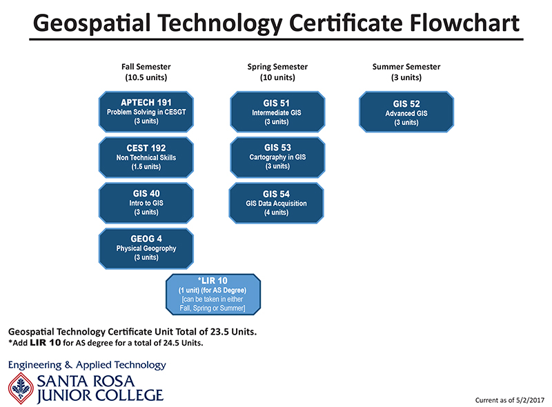
A certificate of achievement will be awarded upon fulfillment of 24.5 units of Geospatial Technology Core Requirements with a grade of "C" or better. To receive an Associate's Degree in Geospatial Technology, additional coursework up to 60+ units is necessary to satisfy general education requirements. Consult a counselor for courses required for an associate’s degree.
It is important that students who are completing an Associate Degree and desire to transfer to a four-year institution meet with a counselor to plan their lower division coursework. While many majors at SRJC are intended to align with lower division major preparation required by California public universities, specific lower-division major requirements vary among individual campuses. See a counselor, visit the Transfer Center, and ASSIST websites to review transfer preparation guides for specific schools and majors.
See the official Geospatial Technology Certificate HERE.
See the official Geospatial Technology (AS) major HERE.
Geospatial (GIS) Technology Program Courses Flowchart (will be updated soon)
Program Student Learning Outcomes
Upon successful completion of this certificate, the student will be able to:
- Define and describe geospatial terminology, methods, procedures, standards and technology;
- create, edit and analyze geographic, spatial and remotely sensed data;
- communicate clearly and effectively in oral, written and graphic formats;
- prepare layouts, reports, charts and graphs to support different geospatial applications;
- produce finished quality maps representing a basic analysis, a basic survey or a basic scale-based, descriptive, diagrammatic summary;
- create a Geographic Information System (GIS) map following standard cartographic principles which can be utilized within a professional portfolio;
- demonstrate analytical, critical thinking and decision-making skills in geographic information science and technology; and
describe the influence/effect that geospatial science and technology has on the local, regional, national and global communities.
Course Prerequisites and Advisories:
Courses in a program of study may have prerequisites or advisories; that is, courses that must or should be completed before taking that course. Please check for prerequisites or advisories by clicking on the course numbers in the Program Requirements section.
Notes:
It is recommended that students who have not had high school courses in mathematics through plane geometry take the Math placement test and enroll in an appropriate course (eg, CSKLS 371, CSKLS 372, MATH 150A & B, or MATH 151) prior to enrolling in certificate program courses.
For students with limited computer literacy, CS 101A OR CS 101B is recommended. Please contact the department or a counselor for more information.
Civil Engineering, Geospatial & Surveying Technology Programs Coordinator:
Reg Parks
Office Phone #: (707) 527-4376
E-mail: rparks@santarosa.edu